What is every local hiker’s favorite thing about Boulder? Without a doubt, it’s the 145 miles of trails within city limits. Whether you’re looking for a leisurely stroll or a lung-busting climb, it’s all right here. But even hiking homebodies need a change of scenery now and then. It’s time to hit the road and head west to Indian Peaks Wilderness – the backyard to Boulder’s backyard.
Indian Peaks Wilderness is the place to go when you want to kick it up a notch and still be home in time for dinner. When Boulder’s 8,000-foot peaks aren’t doing it for you, Indian Peaks has you covered with challenges both bigger and badder.
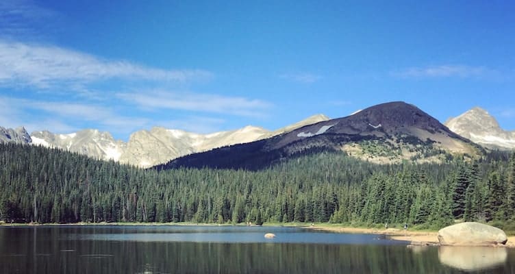
Enter Mount Audubon (13,223 ft). Named for the famous naturalist and painter, Audubon is a classic 13er with a well-traveled passage and plenty of time above tree line. A hike to its summit is the perfect balance of physical challenge and sweet reward. Imagine 360-degree mountain views in exchange for the same mileage and elevation gain as Bear Peak. That’s Mount Audubon. And it’s all within an hour’s drive. Get ready for a field trip to this pristine Indian Peaks beauty.
Get there
From Boulder, take CO-119 west to Nederland and follow signs for the Peak-to-Peak Highway (SR-72). Head north on the Peak-to-Peak and turn left on Brainard Lake Road. Continue to the Mitchell Lake Parking Area.
Brainard Lake Recreation Area is a busy hub for many popular trails. Arrive early to park at Mitchell Lake. If Mitchell Lake is full, you may park at Brainard Lake (this will add 0.8 miles each way).
The trails in Brainard Lake Recreation Area are open year-round, but the road is closed from mid-October to mid-June. When the road is closed, hiking in from the locked gate will add 2.5 miles each way. Please check for current road and trail conditions before heading out.
Hike it
This hike is just under 8 miles with 2,800 feet of elevation gain. More than half of the hike is above tree line, where hikers may be vulnerable to lightening from unpredictable afternoon storms. Be safe. Start early and descend from the summit by 1:00 pm.
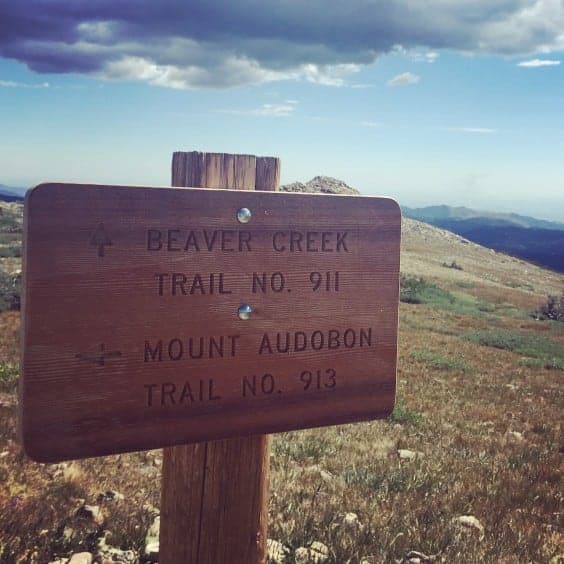
Begin on Beaver Creek Trail at the north end of the Mitchell Lake parking area. The trail begins with gentle switchbacks through a peaceful pine forest. Before long, the tall timbers turn to krummholz and after 1.5 miles you’ll emerge above the tree line. At the fork, stay left to abandon The Beaver Creek Trail and continue on toward Audubon’s summit.
The views are airy and expansive as you continue up. You’ll become familiar with the constant peeping of pikas as they scurry among the talus. The trail has turned from packed dirt to loose gravel and rock. To your left, a snowfield lingers well into the summer’s end. Watch your footing but don’t forget to look up for views of Mount Toll, Navajo Peak, Apache Peak, Shoshoni Peak, and Pawnee Peak.
At approximately 2.7 miles, you’ll reach a saddle with a large cairn. A social trail continues straight ahead to two unnamed peaks. Turn left for the summit push to Audubon. The remaining trek heads up a steep and sometimes unwieldy talus field.

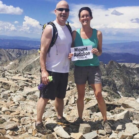
Take a moment to plot your course before pursuing it. Cairns on the north end of the slope will help to keep you on track. Be aware that there are two ridges here that act like false summits. Don’t get too excited until you see one of the 8 wind shelters dotting the true summit. Then you’ll know you’ve arrived.
Enjoy the sweeping panorama of Colorado’s finest and hunker down in one of the stone shelters for a well-earned snack. Final pro-tip: If you borrow someone’s summit sign for a celebratory photo, make sure AUDUBON is spelled correctly.
Happy trails, Boulderites!