For many locals, past and present, Mount Sanitas is the very heart of Boulder’s open space. Just north of downtown, with a variety of trails that make it accessible to all levels, this much loved mountain sees more foot traffic than most. It’s a frequent “first summit” for people who are new to town. It’s part of the weekly rotation for countless others. The trailhead is typically overflowing with a wide range of visitors, from elite ultrarunners to moms with double strollers. And even though many of us claim that we know it like the back of our hand (or the tops of our trail shoes), we keep coming back for more. What makes Mount Sanitas so special? Read on for the story behind Boulder’s favorite hill and detailed descriptions of its network of trails (including the little-known west ridge!). Sanitas is for everyone, so this guide is for you.
The History
The earliest hikers on Mount Sanitas were most likely tuberculosis patients. In 1895, a group of Seventh Day Adventists (led by Dr. John Harvey Kellogg of Kellogg’s Corn Flakes fame) built the Boulder-Colorado Sanitarium and Hospital just east of the current trailhead. This is where Mount Sanitas got its name. Though current Boulderites pronounce Sanitas with a long “ee” and emphasis on the second syllable, Boulderites back in the day pronounced it “SAN-eh-toss” like “sanitarium.”
The Seventh Day Adventists considered the location to be ideal for tuberculosis patients. The spa-like sanitarium provided a strict regimen of diet, exercise, and therapeutic treatments, while Boulder’s dry climate and high altitude was believed to aid in respiratory health. In 1902, the sanitarium built the classic Sanitas trail up to the summit and advertised it in their brochure that year.
Tuberculosis patients were moved to other facilities in town by 1904, and the sanitarium began operating as a health and wellness vacation destination. Visitors were encouraged to hike the Sanitas Trail as part of their stay. Burros (donkeys) were even supplied for visitors who could not make the hike on their own.
In the 1920’s, while the sanitarium was shuttling guests up and down the Sanitas Trail, sandstone was being quarried from the east face to build the University of Colorado’s campus buildings. The wagon road used to haul the sandstone is now the Sanitas Valley Trail.
The sanitarium continued its work until it closed in the 1950’s. The campus evolved throughout the years, and today we know it as the Mapleton Medical Center.
The Trails
The network of trails at Mount Sanitas may be accessed from several points. The two official trailheads are the Sanitas Trailhead and Centennial Trailhead. There are also several neighborhood access points with street parking. With so many interconnected trails, the hiking options are nearly limitless. The descriptions below provide some, but not all, options for loops. Consult the OSMP map to plot the route that works best for you.
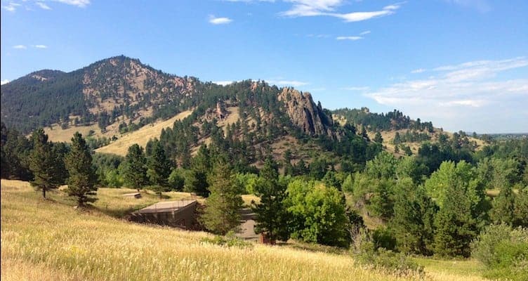
Mount Sanitas Trail (1.6 miles): This is the classic climb to the top. Though Sanitas stands at a mere 6,863 feet, the trail is steep, strenuous, and dotted with false summits. Views of snow-capped peaks to the west and sweeping plains to the right make it worth your while. This trail can be hiked as an out-and-back, or it can be connected with the East Ridge to form a loop. Elevation gain is approximately 1,300 feet.
East Ridge Trail (0.7 miles): The East Ridge is a fun but tricky trail. Be prepared for precarious footing, light scrambling, and some twists and turns. OSMP recently improved their signage due to the numbers of hikers who inadvertently wind up confused and off trail here. Don’t get distracted by the views and you’ll be fine. Some prefer to ascend this trail to the summit, while others prefer taking it down to the valley. You decide. Please note that this trail is notorious for icy patches, so use caution and wear traction in winter.
Sanitas Valley Trail (1 mile): There’s nothing quite like strolling along the Valley Trail. Wide and flat with a gentle but steady rise, it can accommodate both wheelchairs and jogging strollers. It also features benches, a seasonal ditch, and shady trees. This is a wonderful hike in its own right, or you can connect to the other trails for a circle hike. This trail sustained significant damage during the flood. Repairs and cleanup are in progress. Take care to avoid debris and a gully around the halfway point.
Dakota Ridge Trail (1 mile): Dakota Ridge is the kid brother of Mount Sanitas. It runs parallel to the mountain, following the same line, but with a gentler rise and a lesser summit. If you’re short on time or just looking for something more moderate, then Dakota Ridge is the trail for you. Enjoy the view at the top and hike back via the Valley Trail to make a loop. Elevation gain is approximately 500 feet.
Goat Trail (0.6 miles): Located near 3rd Street and Forest Ave, this steep and narrow neighborhood trail offers one more way to access the Sanitas network. Hike up and you’ll find yourself at the junction of three trails. From here you can continue on to the summit via the East Ridge or head down on the Valley Trail or Dakota Ridge.
Unofficial West Ridge Trail (1.5 miles): This trail is not maintained by the city or the county. Drive west on Mapleton Avenue past the primary trailheads. Continue for 1.5 miles on Sunshine Canyon Road. At the first sharp turn, you’ll see a small pullout on the right. This is the only available parking – do not park on Sunshine Canyon Road. The trail begins to the right of the gate and switchbacks its way to the summit, offering a unique perspective not found on the other Sanitas trails. Once at the summit, return the way you came or head down the Mount Sanitas Trail or East Ridge (if you choose the latter options, you’ll need to do a car drop ahead of time).
There you have it. If you weren’t an expert on Sanitas before, you are now. Though it may be the smallest in the Boulder range, Mount Sanitas has secured a big place in the hearts of Boulderites. And it’s easy to see why. With its rich history and numerous trails ranging from novice to expert, Sanitas has something for everyone and that’s why everyone loves Sanitas.
Photo Credit: Alli Fronzaglia